Most prefer to make this a descent - you can use gravel roads in the area to do the climbing. Touches up with FS 5057 making connections over to Buckhorn Gap possible. Very steep, rocky, and technical at the northwest end. Passes through a thinly...
Most people ride this downhill, and for good reason - it's a blast, with a mix of technical, ridge-top and sidehill flowing sections. Some spots near the intersection with Perry Cove Trail have nearly sheer drop-offs on the downhill side of the (very...
This heavily-used trail features incredible views, riding along a needle-sharp ridgeline, and lots of rock outcroppings and boulders. The trail itself is notable for its waterbars, switchbacks, and (unfortunately) heavily eroded sections. Either...
Many creek crossings on the lower end and then it's a stiff, moderately technical, rocky climb to the gap. Some eroded places and waterbars. Merges with and follows a gravel road near the top. Not ridden N. of Buckhorn Gap down to S. Mills R. See...
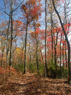
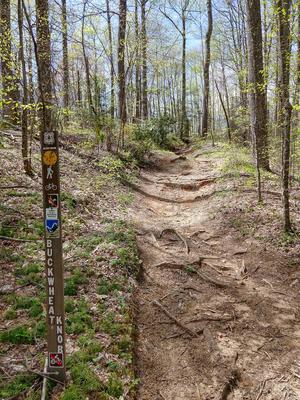
Ridgeline trail which passes some enormous trees. Very steep and technical on south end with switchbacks, waterbars, rocks and roots. North of Buckwheat Knob, the trail is narrow, somewhat less steep, and moderately technical. Passes through...
Seasonal Use Only. Beautiful scenery, fun trail. Starts in Picklesimer Fields...flat, grassy area with crystal clean streamside riding, then a fast, gradual climb, and then a stiff, technical climb up to Butter Gap. Also makes a great downhill from...
In what has to be one of the worst naming decisions in the Pisgah district, the part of this trail which is open to bikes *really* should be Cove Creek. Then, Cove Creek would be open to bikes, Caney Bottom wouldn't, and all would be right in the...
Seasonal/partial use trail; the portion from the Fish Hatchery up to the Butter Gap trail is open to bikes from October 15 - April 15 only. Fairly technical in spots, but more sections are level and fast, with jumps and waterbars in places. Has some...
Follows an old road past an old cemetery on a little plateau near the Davidson River. Lots of white pines & hemlocks, & mountain laurel groves. Some doubletrack & some singletrack; pleasant, short loop.
Only the east half of the loop is open to bikes (and only seasonally). It's moderately steep and rocky; makes for either a fun downhill or a pretty serious climb, especially near the top. A few creek crossings/wet areas can be found near the bottom....
This is an old road bed which goes around the Cove Creek group campground and all the way up to FS 225B. In one of the worst, most confusing naming decisions on the Pisgah district, the lowermost portion of this route south of the Caney Bottom trail...
A terrific, moderately steep, rocky, and technical loop trail. Described here clockwise, it can be ridden either direction.
Follows an old roadbed upstream at the start. Passes an old fish hatchery; starts climbing moderately and becomes quite...
Near the fish hatchery, this is a fun but gradual downhill W to E with jump after jump and the river is far down in the gorge below. Also bypasses a terrible, dusty, hot, sunny climb on FR 475 in either direction. Several landslides in September of...
This new, easy trail follows the Davidson River up from the Lowe's in Brevard, to the Davidson River Campground. Makes it possible to ride from downtown Brevard onto Pisgah's trail system without following a road. Easy; nearly level; hard packed...
Typically ridden downhill, this trail is a beloved Pisgah classic. It starts with a few short twists and turns through the high, cool ridge-top forest in a generally northerly direction. The trail then becomes a legendarily steep descent with a...
An old road bed that is becoming a trail again. Moderate climb near the junction with Thrift Cove, with some jumps; levels out near the junction with Sycamore Cove. Gravel sections. The open forest along the trail is filled with Appalachian Hill Cane...
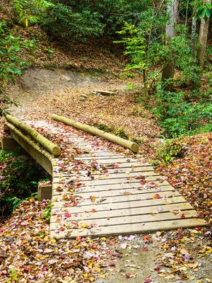
Hilly and fast in places, with nice scenery, roots and rocks, stacked parallel logs for erosion control, narrow log bridges, several creek crossings, rhododendron tunnels, and waterbars A very fun trail. Part of the Picklesimer Fields ride.
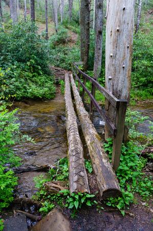
Seasonal use only (October 15 - April 15). Short, steep climb from Davidson River up to intersection with North Slope Connector. Has waterbars, several neat bridges over gulches, rooty sections, rhododendron tunnels, and banked curves. A fun downhill...
Seasonal Use Only. Note: only north half of loop is open to bikes. Rhododendron & Mtn. Laurel tunnels. Trail travels through some open fields on old, narrow roadbed. Undulates up and down near beginning at picnic area; then drops thru a fun...
Short connector from Sycamore Cove to Thrift Cove/Grassy Road. Only this portion is open to bikes (not the portion connecting down to Black Mountain trail).
Substantial climbs with technical, short but very rooty sections. A fun downhill with several creek crossings - on one the trail becomes the creek for a few dozen feet. Wintertime views of Brevard.
Long ridgeline trail which undulates up and down over the various knobs on its summit. Very steep in places; has some issues with erosion as well. It winds onto the edge of private land in places; stay on the trail. Enables a connection with trails...


")