Turkey Pen Gap Trail

At A Glance


5.5 mi one-way
Difficulty Rating: 5.5 ![]()
Steepness: Hilly ![]()
Tread Condition: Moderately Rough ![]()
Blaze Color: Blue
Trail Number: 332
Description
Long ridgeline trail which undulates up and down over the various knobs on its summit. Very steep in places; has some issues with erosion as well. It winds onto the edge of private land in places; stay on the trail. Enables a connection with trails in the Davidson River area via the Black Mtn. trail.
Intersecting Trails
This trail is located in the Mills River area. For a list of all the trails in that area, see the Mills River trails list page.
This trail also crosses into these trailhead areas:
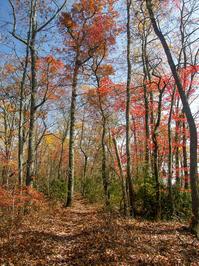
All Photos from the Trail


GPS Map
Map Information
Download GPS Data
Click on a route, trail, or point on the map and select the GPS Data tab to download its data.
Data Formats
KML (Google Earth)
KML is the main file type used by Google Earth. If you have Google Earth installed, clicking the KML link should open the trail or point directly in Google Earth for viewing. This is the native file format used by Google Earth, but many other map applications can use and understand KML as well, so if you're not sure which one to download, KML is a good bet.
GPX
The GPX format stands for GPS Exchange - a free, open, XML format for exchanging GPS and map data. GPX is compatible with Google Earth, many other mapping programs, and most GPS devices (such as Garmin). Load the file directly into your GPS to help find your way on your next trip!
GeoJSON
GeoJSON is a newer, lightweight data exchange format which can be used to quickly share map data and may have a smaller size than KML or GPX. Many professional mapping and GIS applications support the GeoJSON format.
About the Map
Copyright
Base Layers
Base layers provided by OpenStreetMap, the US Geological Survey, the US Forest Service, and NC OneMap. Base layer images are subject to the respective copyright policies of their owners. Base layers may not be available at all times due to system maintenance or outages.
WNCOutdoors Base Layer
The WNCOutdoors Base layer is provided by WNCOutdoors.info. It is licensed by Creative Commons Attribution 3.0.
Trail and Marker Overlays
Trail layers and downloadable data are all original works created by WNCOutdoors with guidance from a variety of sources, including ensembles of our own GPS tracks, user contributed GPS tracks, official maps and GIS data from government agencies, and field observations. WNCOutdoors data is made freely available under the Open Database License - you are free to copy and use it for any purpose under the terms of that license (summary).
Tips
- Hover over a trail to see it highlighted. Helps to see start and end points for an individual trail.
- Scroll and zoom the map before printing, and that view will persist into the printed image.
- Click a trail for more details and to download it individually.
Trail Segments
Trails are often made up of several connecting paths which may have different characteristics, allowed uses, and seasons. This trail is divided into multiple segments as follows:
Turkey Pen Gap - Turkey Pen to Wagon Road Gap
- Allowed Uses: Hiking, Mountain Biking
- Length: 2.42 mi
Turkey Pen Gap - Wagon Road Gap to Black Mtn Tr
- Allowed Uses: Hiking, Mountain Biking
- Length: 2.94 mi
Total Calculated Length: 5.36 mi
This value is derived from our underlying map data, and it may not match officially published information.
Feedback
Ratings
Average Rating: 2.2 (rated 81 times)
Rate It Now:

RM said: Not a hike for the beginner. Trail stairs out steeply, levels a bit, then climbs and climbs and climbs again. Hiked it in the rain. Lots of mud.
JC said: Very rough terrain with lots of steep elevation changes. Would not recommend as a beginner trail as you must be in shape to make this hike. My friend and I enjoy hiking and we've tried many of the trails in the area but this hike was not enjoyable rather 4 hours and 30 mins of 'heavy working out'. I hear the view in the fall is amazing but in the summer there's no reward for your hard work climbing up and down steep slopes. One quarter mile section changes elevation by 600 feet. As a side note we did have about 40 pounds of backpacking gear on each of us.