Trails in the Grandfather Ranger District Trailhead Area

Here is a list of all trails in the Grandfather Ranger District Trailhead area.

Each trail has its own printable page with all the information and links, including (where available):

  • directions to the starting point
  • difficulty
  • length
  • elevation change
  • a map
  • photos from along the way, and
  • a detailed description and trail directions.

For general information about the Grandfather Ranger District trailhead, see the Grandfather Ranger District Trailhead page.

Need to find trails by another method? Go back to Trails.

Heartbreak Ridge Trail

Most Difficult
  • Descends all the way down the Blue Ridge from the Blue Ridge Parkway near Glass Rock Knob to the Star Gap trail not far from the Old Fort Geyser.
  • 3.9mi, Climbs Moderately, Some Obstacles

Point Lookout Trail

Moderate
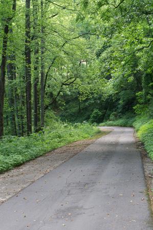
  • This greenway path/trail follows the route of old US Hwy 70 on a steady grade up the Blue Ridge Escarpment from the valley near Old Fort to the top near Ridgecrest. It's a strip of asphalt down the old concrete roadway. Hemmed in by a hardwood and...
  • 3.62mi, Climbs Moderately, Paved

Woodruff Ridge Trail

  • 2.4mi, ,

Young's Ridge Trail

More Difficult
  • Formerly known as Kitsuma or Kitsuma Peak. Starting at its upper end, the trail ascends gently beside I-40 before climbing more steeply through a set of 12 switchbacks approaching the peak, gaining 500ft elevation from the parking area. There are...
  • 4.2mi, Hilly, Some Obstacles