North Boundary Road Trail

At A Glance


3.8 mi one-way
Difficulty Rating: 3.8 ![]()
Steepness: Climbs Moderately ![]()
Tread Condition: Few Obstacles ![]()
Blaze Color: Blue
Trail Number: 135
Description
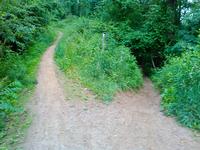
Near the bottom this is a wide gravel road with large water turn-outs which make great jumps if heading downhill. Higher up, as it approaches Ingles Field Gap, the road narrows into doubletrack and even singletrack. Beyond Ingles Field Gap, the trail is singletrack on the old roadbed, but it is extremely overgrown with thorns (or "jaggers"), vines, and poison ivy. High elevation change.
This trail is located in the Bent Creek area. For a list of all the trails in that area, see the Bent Creek trails list page.
All Photos from the Trail


Feedback
Ratings
Average Rating: 2.0 (rated 72 times)
Rate It Now:

No comments yet.