Flat Laurel Creek Ride

Featuring a route that's all above 5000 ft. in elevation, this ride is split into two main parts: a paved road climb and a rough trail descent. Though the descent is never steep, it's extremely rocky and wet, but travels through an incredibly scenic area. Waterfalls, long-range views, and a tunnel round out the list of features you'll find on the ride.
At A Glance
 7.0 mi round-trip
Difficulty Rating: 10.32 ![]()
Tread Condition: Very Rough ![]()
Climb: Climbs Moderately ![]()
Climb Total: 1000 ft
Configuration: Loop using singletrack, doubletrack & paved roads
Starting Point: Black Balsam parking area.
Trails Used: Flat Laurel Creek
Directions
Via the Blue Ridge Parkway
From Asheville, get on the Blue Ridge Parkway heading South. The quickest way to do this is to take I-240 West to I-26 East to Brevard Road (NC 191, exit 33). Turn left at the end of the ramp and follow Brevard Road about 2.4 miles. Turn right at the light at the entrance to the NC Arboretum/Blue Ridge Parkway ramp. Bear left up the ramp and then turn right (South) on the Parkway. Go 29.6 miles (past Graveyard Fields) and turn right on the ramp for NC 215. Turn left (north) at the bottom of the ramp. Go 0.8 mi. to the Flat Laurel Creek trailhead on the right (a gravel road between sections of guardrail).
Via NC Hwy. 215
From Asheville, take I-240 west to I-40 west for 12.6 miles to exit 33, Newfound Road. Turn left at the end of the ramp and go 1.9 miles (the name changes to Newfound St. as you head into Canton.). Turn left onto Bridge Street and go 0.1 mi. past the paper mill on your right. Bear right onto Church St. (US 19/23) and go 1 block, then bear right onto Park St. to stay on 19/23 and go 0.3 mi. Turn left onto Sorrels St. (NC 110) which crosses Main St. and becomes Pisgah Dr. after 400 ft. Go 0.4 mi. and turn right to stay on Pisgah Dr./NC 110. Go 5 miles on NC 110; at the US 276 junction continue straight and the road becomes NC 215. Reset your odometer; it's 17.1 mi. beyond US 276 on NC 215 past Lake Logan and up the mountain in Pisgah National Forest to the Flat Laurel Creek trailhead on the right.
If there's no space to park at the Flat Laurel Creek trailhead, there are some additional parking spots between the Flat Laurel Creek trailhead and the Blue Ridge Parkway, any of which would also work just fine for this ride.
Details
Ride Description

It's possible to ride the Flat Laurel Creek trail as an out-and-back; however, by using NC 215, the Blue Ridge Parkway, and FS 816 (paved roads), you can turn the ride into a loop and vary the scenery a bit. That's how this ride is described.
From the Flat Laurel Creek trail, ride NC 215 South toward the Blue Ridge Parkway, uphill. From here until a little ways past the Devil's Courthouse tunnel on the Parkway, the ride is all uphill - and, even though it's paved, the climb is quite stiff. This part of NC 215 follows the headwaters of Bubbling Spring Branch, with some scenic cascades. Turn right at the intersection with the Blue Ridge Parkway access ramp and then left (north) onto the Parkway itself.
Riding through more spruce-fir forests on the parkway, you will pass by Devils Courthouse mountain and tunnel. An optional side hike up Devil's Courthouse would take you through the endangered spruce-fir environment to the spectacular clifftop summit. Past the Devil's Courthouse tunnel, the Parkway levels out and begins heading downhill some, passing through more of the rugged, scenic high elevation environment.
The surrounding mountaintops you see are typical of mountain "balds" found in the area. Their grassy summits provide great vistas, and it sometimes even appears as if they have a treeline, although it's not a true one. Trees can grow all the way to the tops of mountains in the southern Appalachians - they'd have to be several thousand feet taller to extend into the true alpine zone. Unfortunately, there are no bike-legal trails to the balds - you'll have to hike to see them.
In the middle of a good downhill, turn left at FS 816 (Black Balsam Road) and begin another climb. This one winds its way up above the Graveyard Fields valley to the gap between Black Balsam Mountain and Silvermine Bald. There are great views from this stretch of road, and it tops out at the ride's highest point at the parking lot where the Art Loeb trail crosses FS 816. The elevation there is around 5900 ft. The road then descends gently above the Flat Laurel Creek valley on the left to a big parking area at the Ivestor Gap trail. Curve left into the parking area beside the pit toilets and sign boards.
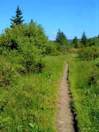
Ride out of the back of the parking lot onto the signed Flat Laurel Creek trail; you'll stay on this trail all the way until its intersection with NC Hwy. 215. The first part of the trail is wide. The route is an old narrow gauge railroad bed which used to lead all the way to the Sunburst campground, far below in the West Fork Pigeon River valley, so the grade is gentle the whole way.
The trail used to be extremely rocky and very technical, and quite wet, but a lot of good work has been done to it recently including a few minor re-routes, reducing these extremes and making it more maintainable. Still, there are a couple of sizable creek crossings and several technical areas to contend with, and it's still pretty rocky and almost always has soggy spots. You'll probably get wet and muddy on this one.
The grade is gentle the whole way; the only steep parts are at a couple of eroded gullies. There are two intersections with hiking-only trails along the route. The first is with the Little Sam trail, on the left. Bear right, downhill, to stay on the Flat Laurel Creek trail. The second is with the Sam Knob trail on the right, which crosses Flat Laurel Creek. You might not even notice it, but stay straight on the Flat Laurel Creek trail if you do.
After the crossing of Bubbling Spring Branch in a deep pool, you'll ride uphill for a short distance on an old road bed, through a camp site, before intersecting NC Hwy. 215.
The trail is definitely fun, but one of the things that makes this ride more interesting is that it is entirely above 5000 feet - one of the few high-elevation trails open to bikes in the region. It travels through a rare and interesting environment for the Southern US.
When starting out on the trail, you will see a dense spruce-fir forest to your left. Most of of the trees are Red Spruce, however, instead of Fraser Fir. This is because the firs have been attacked by a non-native bug called the Balsam Wooly Adelgid, which has wiped out most of the mature firs. A few tall ones still survive here - some of the few remaining mature Firs in the region, actually.
To your right are open meadows with only scattered trees and shrubs, with the imposing Sam Knob in the background. Normally, these meadows would also be forested, but devastating fires burned the valley years ago, killing the forest and sterilizing the soil. This is similar to what happened across the ridge at the well-known Graveyard Fields area.
It's possible that the fires made it up to the railroad grade but didn't make it across, or that the area on the left side of the road was re-planted, or somewhat of a combination of both. Either way, it's a stark contrast from left to right on the upper part of the trail.
The forest is slowly regaining a foothold in the meadows. Some of the glades are brimming with wildflowers, and if you visit in mid to late August, you'll find blueberries growing in profusion on both sides of the trail. As you descend, the forest fills in on both sides of the trail and becomes a mixture of hardwoods and evergreens, interspersed with openings. One particularly scenic stretch of trail passes through a stand of nearly-pure yellow birch trees with ferns growing underneath. It vaguely reminds me of some Aspen forests in the Rockies.
The trail meets and follows the gently winding Flat Laurel Creek downstream. The creek flows out of the flat area, between Sam and Little Sam Knobs, and then drops into the West Fork valley below. There are several unnamed waterfalls on the creek to your right. A short distance beyond the falls on Flat Laurel Creek, another waterfall called Wildcat Falls appears on a tributary to the left, flowing under old concrete bridge you will cross. There are nice long-range views from this stretch of trail, too.
All Photos from This Ride


Map
Green highlight indicates the route to follow within the trail network for this ride.
Tip: Printing this map? You can pan and zoom the map as desired before printing to show the area you need.
Map Information
Download GPS Data
Click on a route, trail, or point on the map and select the GPS Data tab to download its data.
Data Formats
KML (Google Earth)
KML is the main file type used by Google Earth. If you have Google Earth installed, clicking the KML link should open the trail or point directly in Google Earth for viewing. This is the native file format used by Google Earth, but many other map applications can use and understand KML as well, so if you're not sure which one to download, KML is a good bet.
GPX
The GPX format stands for GPS Exchange - a free, open, XML format for exchanging GPS and map data. GPX is compatible with Google Earth, many other mapping programs, and most GPS devices (such as Garmin). Load the file directly into your GPS to help find your way on your next trip!
GeoJSON
GeoJSON is a newer, lightweight data exchange format which can be used to quickly share map data and may have a smaller size than KML or GPX. Many professional mapping and GIS applications support the GeoJSON format.
About the Map
Copyright
Base Layers
Base layers provided by OpenStreetMap, the US Geological Survey, the US Forest Service, and NC OneMap. Base layer images are subject to the respective copyright policies of their owners. Base layers may not be available at all times due to system maintenance or outages.
WNCOutdoors Base Layer
The WNCOutdoors Base layer is provided by WNCOutdoors.info. It is licensed by Creative Commons Attribution 3.0.
Trail and Marker Overlays
Trail layers and downloadable data are all original works created by WNCOutdoors with guidance from a variety of sources, including ensembles of our own GPS tracks, user contributed GPS tracks, official maps and GIS data from government agencies, and field observations. WNCOutdoors data is made freely available under the Open Database License - you are free to copy and use it for any purpose under the terms of that license (summary).
Tips
- Hover over a trail to see it highlighted. Helps to see start and end points for an individual trail.
- Scroll and zoom the map before printing, and that view will persist into the printed image.
- Click a trail for more details and to download it individually.
Feedback
Ratings
Average Rating: 3.0 (rated 1 times)
Rate It Now:

Trevor G said: Trail was ok, it was somewhat technical. All the rocks prevented any good downhill runs. Pretty straight, not many turns. We went all the way to the bottom and rode back up. I probably wouldn't ride it again unless we started at the bottom or took two cars send shuttled up. Crossed this trail off the list, but there are definitely better options in the area.