Cove Creek Trail

At A Glance


2.6 mi one-way
Difficulty Rating: 2.6 ![]()
Steepness: Climbs Moderately ![]()
Tread Condition: Some Obstacles ![]()
Blaze Color: Yellow
Trail Number: 340
Description
This is an old road bed which goes around the Cove Creek group campground and all the way up to FS 225B. In one of the worst, most confusing naming decisions on the Pisgah district, the lowermost portion of this route south of the Caney Bottom trail intersection - the portion which bypasses the Cove Creek group campground, no less - is called Caney Bottom instead.
Most people make a loop out of this trail by climbing FS 475B (Headwaters Road), FS 225, and FS 225B to the top and coming downhill on Cove Creek trail. Keep right at the Caney Bottom trail junction (and you're now on the Caney Bottom trail).
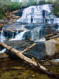
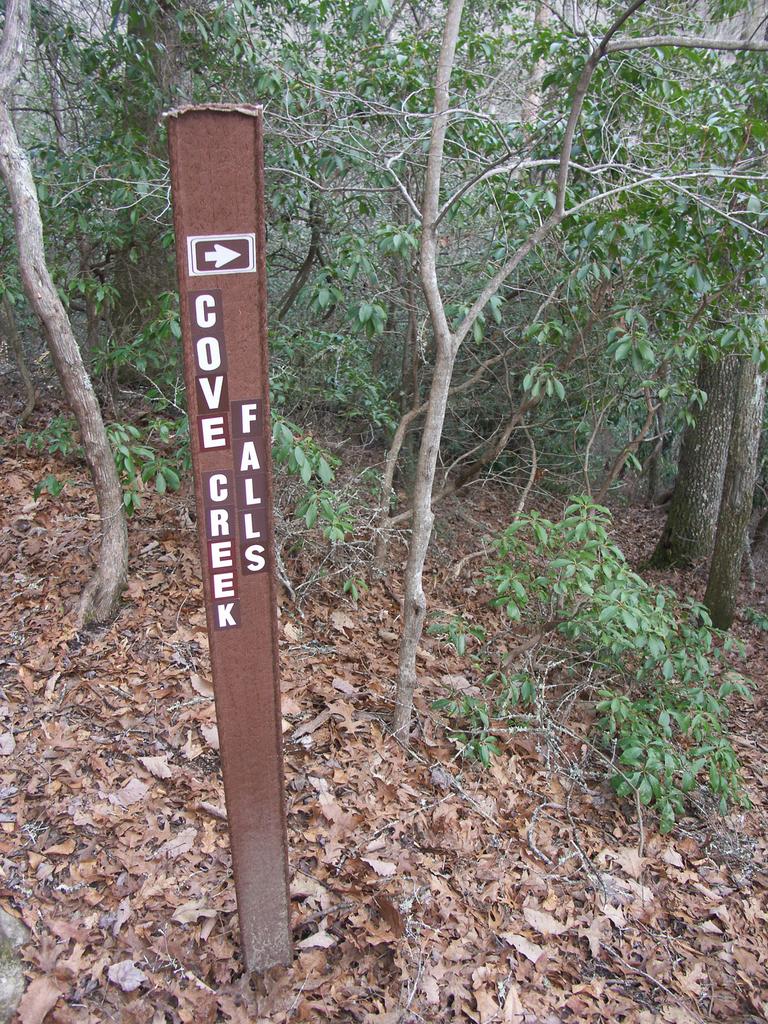
Going this way, it's a fast, downhill singletrack ride along an old road bed, with technical sections and some great banked curves. It also has a creek crossing or two. Several log bridges force you to dismount and carry right in the middle of the good downhill, though, and there's an uphill section past the upper Caney Bottom intersection. You can take the (hiking only) side path to Cove Creek Falls for a nice stop near the end of the ride (but it'll interrupt your downhill).
Intersecting Trails
This trail is located in the Davidson River area. For a list of all the trails in that area, see the Davidson River trails list page.
All Photos from the Trail


GPS Map
Map Information
Download GPS Data
Click on a route, trail, or point on the map and select the GPS Data tab to download its data.
Data Formats
KML (Google Earth)
KML is the main file type used by Google Earth. If you have Google Earth installed, clicking the KML link should open the trail or point directly in Google Earth for viewing. This is the native file format used by Google Earth, but many other map applications can use and understand KML as well, so if you're not sure which one to download, KML is a good bet.
GPX
The GPX format stands for GPS Exchange - a free, open, XML format for exchanging GPS and map data. GPX is compatible with Google Earth, many other mapping programs, and most GPS devices (such as Garmin). Load the file directly into your GPS to help find your way on your next trip!
GeoJSON
GeoJSON is a newer, lightweight data exchange format which can be used to quickly share map data and may have a smaller size than KML or GPX. Many professional mapping and GIS applications support the GeoJSON format.
About the Map
Copyright
Base Layers
Base layers provided by OpenStreetMap, the US Geological Survey, the US Forest Service, and NC OneMap. Base layer images are subject to the respective copyright policies of their owners. Base layers may not be available at all times due to system maintenance or outages.
WNCOutdoors Base Layer
The WNCOutdoors Base layer is provided by WNCOutdoors.info. It is licensed by Creative Commons Attribution 3.0.
Trail and Marker Overlays
Trail layers and downloadable data are all original works created by WNCOutdoors with guidance from a variety of sources, including ensembles of our own GPS tracks, user contributed GPS tracks, official maps and GIS data from government agencies, and field observations. WNCOutdoors data is made freely available under the Open Database License - you are free to copy and use it for any purpose under the terms of that license (summary).
Tips
- Hover over a trail to see it highlighted. Helps to see start and end points for an individual trail.
- Scroll and zoom the map before printing, and that view will persist into the printed image.
- Click a trail for more details and to download it individually.
Trail Segments
Trails are often made up of several connecting paths which may have different characteristics, allowed uses, and seasons. This trail is divided into multiple segments as follows:
FS 225B to Upper Caney Bottom Intersection
- Allowed Uses: Hiking, Mountain Biking
- Length: 219 ft
Upper Caney Bottom Intersection to Cove Creek Falls
- Allowed Uses: Hiking, Mountain Biking
- Length: 1.58 mi
Cove Creek Falls to Lower Caney Bottom Intersection
- Allowed Uses: Hiking, Mountain Biking
- Length: 0.35 mi
Total Calculated Length: 1.97 mi
This value is derived from our underlying map data, and it may not match officially published information.
Feedback
Ratings
Average Rating: (rated 0 times)
Rate It Now:

Skye Barkschat said: No idea if uses are strictly monitored, but in a Forest Service area, it's not a bad idea to follow the signs, because they put them up specifically to control the natural environment, to keep it as natural as is possible & thus as healthy as possible, thus in as good of a shape for riding as they can for u!
Ed Cope said: So, when we rode this, Caney Bottom trail was marked as prohibited for bike use. Is this a seasonal situation? Or has something changed?