Big Ivy Tour (Coleman Boundary) Ride

The best way to explore the area, this long, spectacular ride combines the Staire Creek and Douglas Falls rides above into one great "figure 8" loop.
At A Glance
 16.2 mi round-trip
Difficulty Rating: 23.23 ![]()
Tread Condition: Moderately Rough ![]()
Climb: Climbs Steeply ![]()
Climb Total: 2500 ft
Configuration: Figure 8 loop with an out and back extension (partly hiking only). Travels a long gravel road, a grassy roadbed, and a downhill on steep, technical, rocky singletrack.
Starting Point: Corner Rock picnic area on FR 74 near Barnardsville, NC
Trails Used: Walker Creek, Bear Pen, Laurel Gap, Douglas Falls, Staire Creek
Directions
From Asheville, take US 19-23 north (4-lane) for just over 12 miles. Take exit 15 for NC 197 (Jupiter/Barnardsville). Turn right toward Barnardsville and follow NC 197 (2-lane highway) about 6 miles to the town of Barnardsville. Turn right onto Dillingham Road just past the fire station. It's about 5 miles to the National Forest - stay on Dillingham Road. You will cross a one-lane bridge and the road will turn into gravel FS 74 (there is a sign for Big Ivy). Park at the picnic area, about .4 mi up this road, on the right, across a concrete bridge.
Details
Ride Description
Note: major maintenance work was started on Staire Creek trail in Fall 2015 and the Forest Service has announced its closure to horses and bikes while that is completed. Expected re-opening is March 2016.
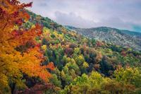
Ride out of the picnic area parking lot, cross the concrete bridge, and turn right on FS 74. This starts out as a gentle climb, but becomes quite steep quite quickly. The road passes through a beautiful cove hardwood forest above Corner Rock Creek - some of the trees growing here are enormous. Several trickling tributaries join the creek from the left. After nearly two miles of relentless climbing, the road will curve right and level out (ahhh...), cross Corner Rock Creek, and resume the climb up the opposite valley wall (groan...) through more lush second growth forest. In the fall, this forest becomes a tunnel of color. The road will round the ridge and pass into a cove to cross Little Andy Creek. The climb moderates some here, allowing you to catch your breath and enjoy what is nearly a temperate rain forest that surrounds you. After rounding Big Andy Ridge, the road will begin a fast downhill section. At the bottom of this is a huge cliff face on the left, called Snake's Den Rock, that is a very popular rock climbing spot. A good view opens up to the right here. Resuming a moderate climb, you will begin to hear Walker Branch roaring in the cove below. Appearing to the left as you catch up with the stream is cascading Walker Falls. The road goes right past the base of the falls, which are most impressive after wet weather but attractive anytime. 0.1 mile further is another small falls on the left. Climbing gently, the road will next round Walker Ridge. An easy ride from here will take you to the signed intersection with the Staire Creek trail. The Staire Creek ride veers right at this point, but keep going straight to continue the tour.
From here the road immediately heads downhill, plunging you headlong into the beautiful, lush forest and the Staire Creek watershed. You'll cross a branch of Staire Creek, and a nice cascade is upstream on the left. Gently climbing, you'll cross another rushing tributary of Staire Creek. Another follows. Just before you make this crossing, though, look right (downstream from where you'll cross) and you can catch a glimpse of a cascading waterfall. Finally, you will cross the last branch of Staire Creek; another waterfall is small but just off the roadside to the left. By now you are heading for the crest of Locust Ridge, which tries to dry out but can't help but to sprout a strong spring, roadside left. It is piped, but resist the urge to guzzle the cold, clear water without treating it (nasty life forms may or may not live in the water). Continue on around the relatively flat ridge, gently climbing. This ridge is long, and divides two large watersheds. The one you are heading into is even more rugged and remote than the one you've been in. Heading back toward the next cove, you will pass by the entrance to the Laurel Gap "trail." Keep straight to begin the out-and-back portion of the ride. The road will undulate and begin crossing creeks again, where (you guessed it) there are more cascades. You'll start climbing along Bullhead Ridge, which will take you to a graffiti covered concrete wall on the right. Just past this, the road finally dead ends in a parking lot.
Leading out of the back of the parking lot is the Douglas Falls trail. It is HIKING ONLY! Leave your bike (preferably locked to a sturdy tree) and walk down this easy trail about .5 mi. to the falls. A sight well worth the diversion, the stream plunges off a huge overhanging rock bluff, falling 70 feet through midair in front of a huge rock cave, surrounded by a virgin hemlock forest and gigantic trees. Return along the same trail.
Pick up your bike and head back on FR 74 to the Laurel Gap trail. Turn right onto this grassy old roadbed, which goes uphill, and ride around the gate. From here on out, the ride passes through an area that is very remote, so don't expect to see crowds. In fact, feel lucky if you see another soul. And get used to dripping wet rocks.
The Forest Service seeded this darn road and keeps it mowed. It's long, tedious, and grassy. There's no shade and the soft grass and moss surface saps your energy. It's like riding on a long sponge. If the moss is wet, your tires will be showering you whenever you pick up speed. (Hint: if you see a path starting to wear along this road, ride on it! If we can get some singletrack going on this road, it'd be great!).
The forest here is recently logged and crowded with small trees; you are on the lower fringe of the Northern Hardwood forest zone. Views of the Blue Ridge Parkway far above are possible to the right and ahead of you. The road will head downhill eventually, and you will be able to pick up enough speed to overcome the sponginess and do the turns some justice.
At about mile 12.5 (while the road is still going downhill), be on the lookout for the Bear Pen trail which heads left. It is a signed intersection but you have to be looking for it.
From here, check your brakes - and prepare for nearly 2000 vertical feet of uninterrupted singletrack downhill! Upon making the turn, you are immediately back in the forest on a technical, steep, fun, rocky descent.
The trail follows an old logging roadbed and other old roadbeds do head off in all directions. So it's up to you to stay focused on the right path. It's fairly obvious, because the other roadbeds have large trees growing on them due to lack of use, and as usage has increased in recent years the path is more well-worn than it used to be. But in summer, when the trail can get overgrown in places, pick weeds over trees to stay on track.
Potential navigation issues aside, it's a great downhill. You will reach a wet creek crossing (you actually have to ride through the water -- no pipe here). Next is a great section of trail with many large whoop-te-doo's that launch the willing rider into midair. You'll blast off the end of the Bear Pen trail at the intersection with FS 74.
Ride straight across the road and onto the Staire Creek trail, which goes through a grassy clearing and back into the woods.
Staire Creek trail now proceeds to drop you 1,200' in a little over a mile -- it is very steep and somewhat technical. You'll cross a small tributary, then the trail will pass by a huge rock cave on the right. It will then switchback down onto an old roadbed and follow the scenic, cascading Staire Creek itself which appears to your left.
The trail's steepness moderates some, but it gets quite rocky as it follows the stream downhill and there are some wet and muddy spots. At one point, the rushing water on the left can be heard in stereo as it bounces off a rock face to the right.
At the next intersection, with the Walker Creek Trail, the ride gets much less steep, but much muddier. Next you'll cross Walker Creek -- here it may be difficult to keep your feet dry during wet weather. You will then reach the end of the Walker Creek trail at a junction with a forest road.
Turn right, and follow this gravel road back to the start of the ride to finish.
All Photos from This Ride


Ride Landmarks
| Mile | Directions |
|---|---|
| Start | Ride out of the parking lot, turn right, and turn right again on FR 74 to begin riding uphill. |
| 1.8 | Road flattens, curves and crosses Corner Rock Creek, then resumes the climb. |
| 3.2 | FR 74 begins downhill after going around Big Andy Ridge. |
| 3.6 | Bottom of downhill; Snake's Den Rock is on the left. Road resumes climbing. |
| 3.9 | Walker Falls is on the left. |
| 4.6 | Road curves around the crest of Walker Ridge and becomes more level. |
| 5.2 | Intersection with Staire Creek trail. Continue south along FR 74, which goes downhill. |
| 5.4 | Cross a branch of Staire Creek. A cascade is on the left. |
| 5.7, 5.8, & 6.2 | Cross three more branches of Staire Creek, with cascades and falls on each. |
| 6.7 | Piped spring is on the left. |
| 7.6 | Pass the Laurel Gap Trail to begin the out-and-back portion of the ride. |
| 8.6 | Graffiti covered concrete wall is on the right. |
| 8.7 | Road dead-ends in a parking lot. Trail to Douglas Falls (~0.5 mi) is HIKING ONLY! Park your bike and walk out to the falls. Return to your bike and ride back to the Laurel Gap trail intersection. |
| 9.9 | Intersection with the Laurel Gap trail again. Turn right, riding onto the grassy old roadbed and around a gate. |
| 12.5 | Intersection with the Bear Pen trail. Turn left. |
| 13.3 | Wet creek crossing. |
| 14.1 | Intersection with FR 74. Ride straight across, and pick up the Staire Creek trail on the other side, which will pass through a grassy clearing and begin downhill. |
| 14.8 | Middle of the steep downhill. Trail passes a large rock cave on the right. |
| 15.2 | Intersection with the Walker Creek trail. Turn left. |
| 15.5 | Crossing of Walker Creek; may require wading if the water is up. |
| 15.8 | End of Walker Creek trail. Turn right on the gravel road. |
| 16.2 | Finish; turn right into the picnic area parking lot. |
Map
Green highlight indicates the route to follow within the trail network for this ride.
Tip: Printing this map? You can pan and zoom the map as desired before printing to show the area you need.
Map Information
Download GPS Data
Click on a route, trail, or point on the map and select the GPS Data tab to download its data.
Data Formats
KML (Google Earth)
KML is the main file type used by Google Earth. If you have Google Earth installed, clicking the KML link should open the trail or point directly in Google Earth for viewing. This is the native file format used by Google Earth, but many other map applications can use and understand KML as well, so if you're not sure which one to download, KML is a good bet.
GPX
The GPX format stands for GPS Exchange - a free, open, XML format for exchanging GPS and map data. GPX is compatible with Google Earth, many other mapping programs, and most GPS devices (such as Garmin). Load the file directly into your GPS to help find your way on your next trip!
GeoJSON
GeoJSON is a newer, lightweight data exchange format which can be used to quickly share map data and may have a smaller size than KML or GPX. Many professional mapping and GIS applications support the GeoJSON format.
About the Map
Copyright
Base Layers
Base layers provided by OpenStreetMap, the US Geological Survey, the US Forest Service, and NC OneMap. Base layer images are subject to the respective copyright policies of their owners. Base layers may not be available at all times due to system maintenance or outages.
WNCOutdoors Base Layer
The WNCOutdoors Base layer is provided by WNCOutdoors.info. It is licensed by Creative Commons Attribution 3.0.
Trail and Marker Overlays
Trail layers and downloadable data are all original works created by WNCOutdoors with guidance from a variety of sources, including ensembles of our own GPS tracks, user contributed GPS tracks, official maps and GIS data from government agencies, and field observations. WNCOutdoors data is made freely available under the Open Database License - you are free to copy and use it for any purpose under the terms of that license (summary).
Tips
- Hover over a trail to see it highlighted. Helps to see start and end points for an individual trail.
- Scroll and zoom the map before printing, and that view will persist into the printed image.
- Click a trail for more details and to download it individually.
Feedback
Ratings
Average Rating: 5.0 (rated 1 times)
Rate It Now:

mark said: great combination of straight up work-out and technical fun. Ride landmarks make it sound more complicated than it really is. Trails on the way down are not marked, so keep track of your miles. ...Walker Creek Trail seemed quite a bit further that what is suggested. great ride!
Dennis said: Rode this last week - too many horses, dogs, and hikers for my taste.
Jay said: Just rode this, and loved it! The only reason it is rated most difficult is probably because of the length of the trail. Staire Creek was pretty technical, but it was also a ton of fun!